Spatial Joins
A spatial join uses binary predicates
such as intersects and crosses to combine two GeoDataFrames based on the spatial relationship
between their geometries.
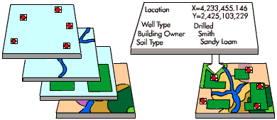
A common use case might be a spatial join between a point layer and a polygon layer where you want to retain the point geometries and grab the attributes of the intersecting polygons.
from IPython.core.display import Image
Image(url='https://web.natur.cuni.cz/~langhamr/lectures/vtfg1/mapinfo_1/about_gis/Image23.gif')
Types of spatial joins
We currently support the following methods of spatial joins. We refer to the left_df and right_df which are the correspond to the two dataframes passed in as args.
Left outer join
In a LEFT OUTER JOIN (how='left'), we keep all rows from the left and duplicate them if necessary to represent multiple hits between the two dataframes. We retain attributes of the right if they intersect and lose right rows that don't intersect. A left outer join implies that we are interested in retaining the geometries of the left.
This is equivalent to the PostGIS query:
SELECT pts.geom, pts.id as ptid, polys.id as polyid
FROM pts
LEFT OUTER JOIN polys
ON ST_Intersects(pts.geom, polys.geom);

                    geom                    | ptid | polyid
--------------------------------------------+------+--------
 010100000040A9FBF2D88AD03F349CD47D796CE9BF |    4 |     10
 010100000048EABE3CB622D8BFA8FBF2D88AA0E9BF |    3 |     10
 010100000048EABE3CB622D8BFA8FBF2D88AA0E9BF |    3 |     20
 0101000000F0D88AA0E1A4EEBF7052F7E5B115E9BF |    2 |     20
 0101000000818693BA2F8FF7BF4ADD97C75604E9BF |    1 |
(5 rows)
Right outer join
In a RIGHT OUTER JOIN (how='right'), we keep all rows from the right and duplicate them if necessary to represent multiple hits between the two dataframes. We retain attributes of the left if they intersect and lose left rows that don't intersect. A right outer join implies that we are interested in retaining the geometries of the right.
This is equivalent to the PostGIS query:
SELECT polys.geom, pts.id as ptid, polys.id as polyid
FROM pts
RIGHT OUTER JOIN polys
ON ST_Intersects(pts.geom, polys.geom);

  geom    | ptid | polyid
----------+------+--------
 01...9BF |    4 |     10
 01...9BF |    3 |     10
 02...7BF |    3 |     20
 02...7BF |    2 |     20
 00...5BF |      |     30
(5 rows)
Inner join
In an INNER JOIN (how='inner'), we keep rows from the right and left only where their binary predicate is True. We duplicate them if necessary to represent multiple hits between the two dataframes. We retain attributes of the right and left only if they intersect and lose all rows that do not. An inner join implies that we are interested in retaining the geometries of the left.
This is equivalent to the PostGIS query:
SELECT pts.geom, pts.id as ptid, polys.id as polyid
FROM pts
INNER JOIN polys
ON ST_Intersects(pts.geom, polys.geom);

                    geom                    | ptid | polyid
--------------------------------------------+------+--------
 010100000040A9FBF2D88AD03F349CD47D796CE9BF |    4 |     10
 010100000048EABE3CB622D8BFA8FBF2D88AA0E9BF |    3 |     10
 010100000048EABE3CB622D8BFA8FBF2D88AA0E9BF |    3 |     20
 0101000000F0D88AA0E1A4EEBF7052F7E5B115E9BF |    2 |     20
(4 rows)
Spatial Joins between two GeoDataFrames
Let's take a look at how we'd implement these using GeoPandas. First, load up the NYC test data into GeoDataFrames:
%matplotlib inline
from shapely.geometry import Point
from geopandas import datasets, GeoDataFrame, read_file
from geopandas.tools import overlay

# NYC Boros
zippath = datasets.get_path('nybb')
polydf = read_file(zippath)

# Generate some points
b = [int(x) for x in polydf.total_bounds]
N = 8
pointdf = GeoDataFrame([
    {'geometry': Point(x, y), 'value1': x + y, 'value2': x - y}
    for x, y in zip(range(b[0], b[2], int((b[2] - b[0]) / N)),
                    range(b[1], b[3], int((b[3] - b[1]) / N)))])

# Make sure they're using the same projection reference
pointdf.crs = polydf.crs
pointdf
| geometry | value1 | value2 | |
|---|---|---|---|
| 0 | POINT (913175 120121) | 1033296 | 793054 |
| 1 | POINT (932450 139211) | 1071661 | 793239 |
| 2 | POINT (951725 158301) | 1110026 | 793424 |
| 3 | POINT (971000 177391) | 1148391 | 793609 |
| 4 | POINT (990275 196481) | 1186756 | 793794 |
| 5 | POINT (1009550 215571) | 1225121 | 793979 |
| 6 | POINT (1028825 234661) | 1263486 | 794164 |
| 7 | POINT (1048100 253751) | 1301851 | 794349 |
| 8 | POINT (1067375 272841) | 1340216 | 794534 |
polydf
| BoroCode | BoroName | Shape_Leng | Shape_Area | geometry | |
|---|---|---|---|---|---|
| 0 | 5 | Staten Island | 330470.010332 | 1.623820e+09 | (POLYGON ((970217.0223999023 145643.3322143555... |
| 1 | 4 | Queens | 896344.047763 | 3.045213e+09 | (POLYGON ((1029606.076599121 156073.8142089844... |
| 2 | 3 | Brooklyn | 741080.523166 | 1.937479e+09 | (POLYGON ((1021176.479003906 151374.7969970703... |
| 3 | 1 | Manhattan | 359299.096471 | 6.364715e+08 | (POLYGON ((981219.0557861328 188655.3157958984... |
| 4 | 2 | Bronx | 464392.991824 | 1.186925e+09 | (POLYGON ((1012821.805786133 229228.2645874023... |
pointdf.plot()
<matplotlib.axes._subplots.AxesSubplot at 0x4f1b0b8>

polydf.plot()
<matplotlib.axes._subplots.AxesSubplot at 0x12991208>

Joins
from geopandas.tools import sjoin
join_left_df = sjoin(pointdf, polydf, how="left")
join_left_df
# Note the NaNs where the point did not intersect a boro
| geometry | value1 | value2 | index_right | BoroCode | BoroName | Shape_Leng | Shape_Area | |
|---|---|---|---|---|---|---|---|---|
| 0 | POINT (913175 120121) | 1033296 | 793054 | NaN | NaN | NaN | NaN | NaN |
| 1 | POINT (932450 139211) | 1071661 | 793239 | 0.0 | 5.0 | Staten Island | 330470.010332 | 1.623820e+09 |
| 2 | POINT (951725 158301) | 1110026 | 793424 | 0.0 | 5.0 | Staten Island | 330470.010332 | 1.623820e+09 |
| 3 | POINT (971000 177391) | 1148391 | 793609 | NaN | NaN | NaN | NaN | NaN |
| 4 | POINT (990275 196481) | 1186756 | 793794 | NaN | NaN | NaN | NaN | NaN |
| 5 | POINT (1009550 215571) | 1225121 | 793979 | 1.0 | 4.0 | Queens | 896344.047763 | 3.045213e+09 |
| 6 | POINT (1028825 234661) | 1263486 | 794164 | 4.0 | 2.0 | Bronx | 464392.991824 | 1.186925e+09 |
| 7 | POINT (1048100 253751) | 1301851 | 794349 | NaN | NaN | NaN | NaN | NaN |
| 8 | POINT (1067375 272841) | 1340216 | 794534 | NaN | NaN | NaN | NaN | NaN |
join_right_df = sjoin(pointdf, polydf, how="right")
join_right_df
# Note Staten Island is repeated
| index_left | value1 | value2 | BoroCode | BoroName | Shape_Leng | Shape_Area | geometry | |
|---|---|---|---|---|---|---|---|---|
| index_right | ||||||||
| 0 | 1.0 | 1071661.0 | 793239.0 | 5 | Staten Island | 330470.010332 | 1.623820e+09 | (POLYGON ((970217.0223999023 145643.3322143555... |
| 0 | 2.0 | 1110026.0 | 793424.0 | 5 | Staten Island | 330470.010332 | 1.623820e+09 | (POLYGON ((970217.0223999023 145643.3322143555... |
| 1 | 5.0 | 1225121.0 | 793979.0 | 4 | Queens | 896344.047763 | 3.045213e+09 | (POLYGON ((1029606.076599121 156073.8142089844... |
| 4 | 6.0 | 1263486.0 | 794164.0 | 2 | Bronx | 464392.991824 | 1.186925e+09 | (POLYGON ((1012821.805786133 229228.2645874023... |
| 2 | NaN | NaN | NaN | 3 | Brooklyn | 741080.523166 | 1.937479e+09 | (POLYGON ((1021176.479003906 151374.7969970703... |
| 3 | NaN | NaN | NaN | 1 | Manhattan | 359299.096471 | 6.364715e+08 | (POLYGON ((981219.0557861328 188655.3157958984... |
join_inner_df = sjoin(pointdf, polydf, how="inner")
join_inner_df
# Note the lack of NaNs; dropped anything that didn't intersect
| geometry | value1 | value2 | index_right | BoroCode | BoroName | Shape_Leng | Shape_Area | |
|---|---|---|---|---|---|---|---|---|
| 1 | POINT (932450 139211) | 1071661 | 793239 | 0 | 5 | Staten Island | 330470.010332 | 1.623820e+09 |
| 2 | POINT (951725 158301) | 1110026 | 793424 | 0 | 5 | Staten Island | 330470.010332 | 1.623820e+09 |
| 5 | POINT (1009550 215571) | 1225121 | 793979 | 1 | 4 | Queens | 896344.047763 | 3.045213e+09 |
| 6 | POINT (1028825 234661) | 1263486 | 794164 | 4 | 2 | Bronx | 464392.991824 | 1.186925e+09 |
We're not limited to using the intersection binary predicate. Any of the Shapely geometry methods that return a Boolean can be used by specifying the op kwarg.
sjoin(pointdf, polydf, how="left", op="within")
| geometry | value1 | value2 | index_right | BoroCode | BoroName | Shape_Leng | Shape_Area | |
|---|---|---|---|---|---|---|---|---|
| 0 | POINT (913175 120121) | 1033296 | 793054 | NaN | NaN | NaN | NaN | NaN |
| 1 | POINT (932450 139211) | 1071661 | 793239 | 0.0 | 5.0 | Staten Island | 330470.010332 | 1.623820e+09 |
| 2 | POINT (951725 158301) | 1110026 | 793424 | 0.0 | 5.0 | Staten Island | 330470.010332 | 1.623820e+09 |
| 3 | POINT (971000 177391) | 1148391 | 793609 | NaN | NaN | NaN | NaN | NaN |
| 4 | POINT (990275 196481) | 1186756 | 793794 | NaN | NaN | NaN | NaN | NaN |
| 5 | POINT (1009550 215571) | 1225121 | 793979 | 1.0 | 4.0 | Queens | 896344.047763 | 3.045213e+09 |
| 6 | POINT (1028825 234661) | 1263486 | 794164 | 4.0 | 2.0 | Bronx | 464392.991824 | 1.186925e+09 |
| 7 | POINT (1048100 253751) | 1301851 | 794349 | NaN | NaN | NaN | NaN | NaN |
| 8 | POINT (1067375 272841) | 1340216 | 794534 | NaN | NaN | NaN | NaN | NaN |