#!/usr/bin/env python # coding: utf-8 # #
# #
# Unidata Logo #
# #

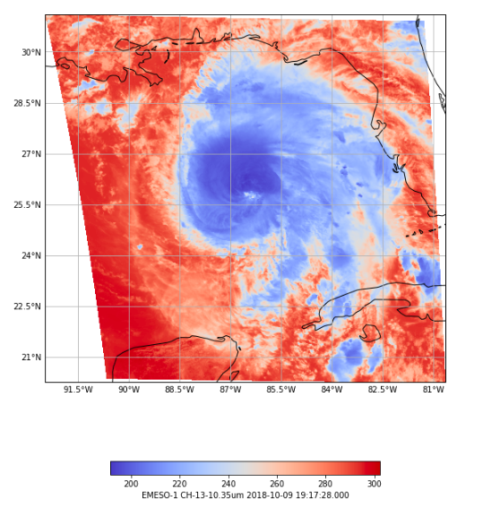
python-awips: Working with Satellite Data

#

Unidata AMS 2021 Student Conference

# #
#
# # --- # #
Colorized GOES East Mesoscale image
# # ### Focuses # # * Investigate what satellite data is available from an EDEX server. # * Define map properties in a function that can be used to plot multiple images. # * Retreive Mesoscale GOES satellite grid data from an EDEX server. # * Use matplotlib pcolormesh to plot the colorized images with a colorbar. # # # ### Objectives # # 1. [Define Data Request](#1.-Define-Data-Request) # 1. [View Optional Identifiers](#2.-View-Optional-Identifiers) # 1. [View Sources](#3.-View-Sources) # 1. [View Creating Entities](#4.-View-Creating-Entities) # 1. [View Sector IDs](#5.-View-Sector-IDs) # 1. [Create a Satellite Product Tree](#6.-Create-a-Satellite-Product-Tree) # 1. [Define Map Properties](#7.-Define-Map-Properties) # 1. [Plot Image Data!](#8.-Plot-Image-Data!) # # --- # ### Imports # In[ ]: from awips.dataaccess import DataAccessLayer import cartopy.crs as ccrs import cartopy.feature as cfeat import matplotlib.pyplot as plt from cartopy.mpl.gridliner import LONGITUDE_FORMATTER, LATITUDE_FORMATTER import numpy as np import datetime # --- # # ## 1. Define Data Request # # If you read through the [python-awips: How to Access Data](https://nbviewer.jupyter.org/github/Unidata/pyaos-ams-2021/blob/master/notebooks/dataAccess/python-awips-HowToAccessData.ipynb) training, you will know that we need to set an EDEX url to access our server, and then we create a data request. In this example we use *satellite* as the data type to define our request. # In[ ]: # Create an EDEX data request DataAccessLayer.changeEDEXHost("edex-cloud.unidata.ucar.edu") request = DataAccessLayer.newDataRequest() request.setDatatype("satellite") # Take a look at our request print(request) # Top # # --- # # ## 2. View Optional Identifiers # # There can be many sources of satellite data stored in an EDEX server. First, let's take a look at the available "identifiers". We will then look a little more in depth at a few of the identifiers. # In[ ]: # get optional identifiers for satellite datatype identifiers = set(DataAccessLayer.getOptionalIdentifiers(request)) print("Available Identifiers:") for id in identifiers: if id.lower() == 'datauri': continue print(" - " + id) # Top # # --- # ## 3. View Sources # # Here, use *source* as the identifier, and take a look at the available sources are. The *source* is a parameter that is set in the netcdf file, and gives some insight to where the product is coming from. # In[ ]: # Show available sources identifier = "source" sources = DataAccessLayer.getIdentifierValues(request, identifier) print(identifier + ":") print(list(sources)) # Top # # --- # ## 4. View Creating Entities # # Next, use *creatingEntity* as the identifier, and take a look at what creating entities are. The *creatingEntity* is related to what instrument or institute created the product. # In[ ]: # Show available creatingEntities identifier = "creatingEntity" creatingEntities = DataAccessLayer.getIdentifierValues(request, identifier) print(identifier + ":") print(list(creatingEntities)) # Top # # --- # ## 5. View Sector IDs # # Next, use *sectorID* as the identifier and take a look at what sectors are available. The *sectorID* is what AWIPS uses to know what geographic section the data is related to. # In[ ]: # Show available sectorIDs identifier = "sectorID" sectorIDs = DataAccessLayer.getIdentifierValues(request, identifier) print(identifier + ":") print(list(sectorIDs)) # Top # # --- # ## 6. Create a Satellite Product Tree # # By cycling through all the identifiers, a detailed overview of all available products can be created. In this example, first *creatingEntity* is used, and then *availableLocationNames*, and *availableParameters* are used to build the product list further. # # > Note: The identifieres *source* and *sectorID* are not used in this tree, but this is only one way to construct such a product overview. # In[ ]: # Construct a full satellite product tree for entity in creatingEntities: print(entity) # Create a new request each time through so only one Identifer is set per request request = DataAccessLayer.newDataRequest("satellite") request.addIdentifier("creatingEntity", entity) # Group by available locations availableSectors = DataAccessLayer.getAvailableLocationNames(request) availableSectors.sort() for sector in availableSectors: print(" - " + sector) request.setLocationNames(sector) # Get all available products availableProducts = DataAccessLayer.getAvailableParameters(request) availableProducts.sort() for product in availableProducts: print(" - " + product) # Top # # --- # ## 7. Define Map Properties # # In order to plot more than one image, it's easiest to define common logic in a function. Here, a new function called **make_map** is defined. This function uses the [matplotlib.pyplot package (plt)](https://matplotlib.org/3.3.3/api/_as_gen/matplotlib.pyplot.html) to create a figure and axis. The coastlines (continental boundaries) are added, along with lat/lon grids. # In[ ]: def make_map(bbox, projection=ccrs.PlateCarree()): fig, ax = plt.subplots(figsize=(10,12), subplot_kw=dict(projection=projection)) if bbox[0] is not np.nan: ax.set_extent(bbox) ax.coastlines(resolution='50m') gl = ax.gridlines(draw_labels=True) gl.top_labels = gl.right_labels = False gl.xformatter = LONGITUDE_FORMATTER gl.yformatter = LATITUDE_FORMATTER return fig, ax # Top # # --- # ## 8. Plot Image Data! # # For this example, use Channel 13 on the two mesoscale sectors from GOES-East satellite. Create a figure to contain the plot. Create a new *Data Request* for each sector and set the location and parameters on it. Limit the data to the most recently acquired image using the *getAvailableTimes* function. Then use pcolormesh to create a plot from the data in the response in the *GridData* object. # # > Note: You may see a warning appear with a red background, this is okay, and will go away with subsequent runs of the cell. # In[ ]: # Specify the sectors - GOES East Mesocales sectors = ["EMESO-1","EMESO-2"] # Create a figure to contain all subplots fig = plt.figure(figsize=(16,7*len(sectors))) # Cycle through the sectors to create and plot recent data from each one for i, sector in enumerate(sectors): # Create the Ch 13 data request request = DataAccessLayer.newDataRequest() request.setDatatype("satellite") request.setLocationNames(sector) request.setParameters("CH-13-10.35um") # Get the available times utc = datetime.datetime.utcnow() times = DataAccessLayer.getAvailableTimes(request) # Get the grid data using the latest time response = DataAccessLayer.getGridData(request, [times[-1]]) grid = response[0] data = grid.getRawData() lons,lats = grid.getLatLonCoords() # Create the bounding box from the grid data bbox = [lons.min(), lons.max(), lats.min(), lats.max()] # Draw a new subplot based on the bounding box fig, ax = make_map(bbox=bbox) # Add state boundaries where available states = cfeat.NaturalEarthFeature(category='cultural', name='admin_1_states_provinces_lines', scale='50m', facecolor='none') ax.add_feature(states, linestyle=':') # Create the color scale cs = ax.pcolormesh(lons, lats, data, cmap='coolwarm') #Create the colorbar and add a label cbar = fig.colorbar(cs, shrink=0.6, orientation='horizontal') cbar.set_label(sector + " " + grid.getParameter() + " " \ + str(grid.getDataTime().getRefTime())) # Top # # --- # ## See also # # Documentation for: # # * [awips.DataAccessLayer](http://unidata.github.io/python-awips/api/DataAccessLayer.html#) # * [awips.PyGridData](http://unidata.github.io/python-awips/api/PyGridData.html) # * [matplotlib.pyplot](https://matplotlib.org/3.3.3/api/_as_gen/matplotlib.pyplot.html) # * [matplotlib.pyplot.pcolormesh](https://matplotlib.org/3.3.3/api/_as_gen/matplotlib.pyplot.pcolormesh.html) # * [matplotlib.pyplot.subplot](https://matplotlib.org/3.3.3/api/_as_gen/matplotlib.pyplot.subplot.html) # # # ### Related Notebooks # # * [python-awips: How to Access Data](https://nbviewer.jupyter.org/github/Unidata/pyaos-ams-2021/blob/master/notebooks/dataAccess/python-awips-HowToAccessData.ipynb) # # Top